Start Point

Gießenbach (connection bike path Seefeld-Scharnitz)

End Point

Gießenbach (connection bike path Seefeld-Scharnitz)

Difficulty

Medium

Total Distance

13,30 km

Descent Meters

447 m

Ascent Meters

447 m

Highest Point

1457 m

Total Time

02:30 h

Map & Elevation Profile

Start Point

Gießenbach (connection bike path Seefeld-Scharnitz)

End Point

Gießenbach (connection bike path Seefeld-Scharnitz)

Difficulty

Medium

Total Distance

13,30 km

Descent Meters

447 m

Ascent Meters

447 m

Highest Point

1457 m

Total Time

02:30 h

Cycling

Best Time

Jan

Feb

Mar

Apr

May

Jun

Jul

Aug

Sep

Oct

Nov

Dec

Mountainbike tour

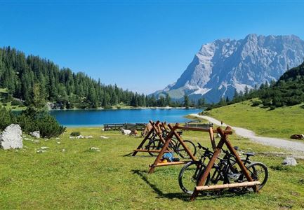
This bike tour takes you through the idyllic Gießenbach valley to the Eppzirler Alm. Experience the idyllic Karwendel mountains and then enjoy home-made food at the mountain hut.

From here, the bike path leads upstream through the idyllic Giessenbach valley. Surrounded by steep rock faces, the wide forest road climbs quite steeply at first, but soon flattens out. The tour then continues moderately along the Giessenbach stream.

At a fork in the path, keep right and move away from the Giessenbach stream. A short, steep ascent here demands your strength once again. But then the road continues through shady woods and across gentle alpine meadows into a small valley floor, framed by the many peaks of the Karwendel.

The last section to the Eppzirler Alm is another gentle ascent. Once there, a magnificent view awaits you. After a refreshment stop at the hut, the return route follows the same path - perfect for enjoying the contrasting landscape once again!

Features & Characteristics

Stamina

Technique

Start Point

Gießenbach (connection bike path Seefeld-Scharnitz)

End Point

Gießenbach (connection bike path Seefeld-Scharnitz)

Videos

Similar Tour Suggestions

Gaistal-Seebensee-Blick-Zugpsitze-und-Seebenalm (c) Anna Rieder

Cycling

Biketour Zugspitz-8

Length

104,00 km

Duration

10:00 h

Uphill

1687 hm

Altitude

1596 hm

Difficulty

Medium

Wildmoos Buchen Ropferstubm

Cycling

Biketour No. 5067 Salzbach-Ropferstub'm

Length

16,40 km

Duration

01:00 h

Uphill

472 hm

Downhill

469 hm

Altitude

1312 hm

Difficulty

Medium

Wildmoos (c) Anna Rieder

Cycling

Biketour No. 5069 Seefeld-Wildmoos

Length

6,30 km

Duration

00:30 h

Uphill

122 hm

Downhill

120 hm

Altitude

1308 hm

Difficulty

Medium

Seebensee mit Raeder im Vordergrund

Cycling

Biketour No. 551 Seebensee

Length

27,60 km

Duration

01:40 h

Uphill

561 hm

Downhill

557 hm

Altitude

1581 hm

Difficulty

Medium

Gravelbiker auf dem Radweg zum Brunschkopf im Sommer (2).jpg

Cycling

Biketour No. 544 Mösern-Wildmoos around the Brunschkopf

Length

11,50 km

Duration

01:30 h

Uphill

300 hm

Altitude

1387 hm

Difficulty

Medium

Möserer See im Frühling - Paar auf Liege vor Möserer Seestube von aus der Entfernung.jpg

Cycling

Biketour Seefeld - Mösern - Wildmoos - Katzenkopf - Fludertal - Seefeld

Length

27,20 km

Duration

04:00 h

Uphill

657 hm

Downhill

651 hm

Altitude

1368 hm

Difficulty

Medium

Pfarrkirche im Sommer - Moesern

Cycling

Biketour No. 5068 Mösern-Brunschkopf

Length

8,90 km

Duration

01:00 h

Uphill

281 hm

Altitude

1496 hm

Difficulty

Medium

E-Bike-Pause-bei-Huette.jpg

Cycling

Bike-connection No. 546 Mösern-Seefeld

Length

10,10 km

Duration

00:30 h

Uphill

207 hm

Altitude

1292 hm

Difficulty

Medium